
Nice toss Christy! I’ve played disc golf at 17,200 feet (Everest Basecamp- see below) but horseshoes at 14K? It was a first for me. Click to enlarge.
After a string of fall storms brought snow to much of the state, winter has been on everyones mind. Usually we’re excited to pull the stuff out of the closet and head up to Castle Peak’s Montezuma Basin for some early season skiing but for some reason we weren’t feeling too motivated by the prospect. We wanted to do something different.
Christy’s goal of climbing the 100 tallest peaks in Colorado is in its homestretch. The weekend before last she got one more behind her by slogging up Mount Silverheels, leaving her with only three to go. We figured that of the three remaining, Horseshoe Mountain, 13,898 feet, might make a good weekend/Halloween outing so off we went. Horseshoe Mountain is in the Mosquito Range, between the towns of Leadville and Fairplay and just south of the 14er Mount Sherman.
Unfortunately, there have been an unusually high number of reported avalanche accidents and incidents this season already. The list is posted here. We hoped to stay off that list so we weren’t looking for anything too spicy and thought Horseshoe, with a couple of routes to pick from, would be a reasonably safe outing. And we figured since it was the summit we were after and not a thrilling descent, we could bring the skis, see what we found and make the call then. If it was too thin we could leave them behind. We knew it was on the receiving end of recent storms but it’s also one of the windiest places in the state and we weren’t sure if the new snow had been blown all the way to Nebraska, as is often the case. In sum– we wanted some snow, but not too much. And that’s exactly what we found, so we went skiing.

“Uh, why is it called Horseshoe?” The couloir is marked and we waited to make the call as to whether or not to climb it until we got closer. One alternate route would have been up the windy ridge to the right(north).

As we neared the couloir we figured it was filled in enough to be climbed but we weren’t sure about the ski. It was pretty thin. We left the option open to descend the mellow north ridge if the snow wasn’t right or the pinch(es) in the couloir were too hard to negotiate.

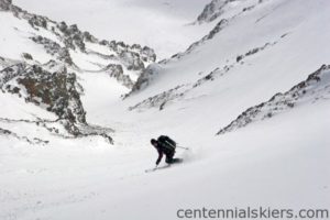
Mount Sherman’s in the background and Christy’s in the pinch of the Boudoir Couloir. It was just barely a ski length wide and not nearly as steep as it looked from afar. We were just happy to be out in the snow.

The standard Mosquito Range sandblasting wind had turned much of the snow into hardpack and sastrugi. Easy for cramponing, generally safe from avalanches but as a ski it isn’t anything to brag about.

Christy leaves her mark in the snow. It’s a nice flat summit, good for a game of horseshoes, though the 40 mph wind kept the game pretty short. We threw the shoe twice.

A ringer! I found the old horseshoe while on a run on Aspen Mountain and thought I’d donate it to its namesake mountain here today.

It’s as wind scoured as it gets around here, the good thing being that you can almost always ski a ribbon of snow down the lee side of the ridges as we did here. In this case it took us right back to the Boudoir, indicated in red down to the left.

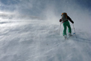
As our first day on the skis the snow was challenging but Christy showed she could keep it together. With little feedback from our snowpack inquiries we were more concerned with hitting rocks than triggering avalanches and we were happy to have our helmets and kneepads.

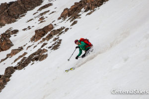
And finally towards the end Christy found a strip of marginally good snow. Desperate? Maybe. For October I say it’s pretty good.
And the parting shot– Jesse Rickert tees off somewhere in the middle of the front nine of the Central Rongbuk Glacier Disc Golf Course– Everest Basecamp, 17,200 feet, Tibet, May 2003. Inspired in part by our desperation to kill time while acclimatizing for our Everest climb, we can’t verify it but believe the improvised 18 holes we put together here might be the highest disc course in the world. Anyone know of one higher?

Fore! Unfortunately for Jesse he sliced his tee shot into the water and he had to wade into the near frozen glacial tarn to retrieve his disc. Mulligans? No way, it cost him a stroke. Nice backdrop, eh?


4 Comments
Leave your reply.