
The Henry Mountains from the north as we drove past the Maze and Goblin Valley. Surrounded by canyon country in all directions, it feels kind of strange as you approach them with the goal of skiing in mind.
“So then what are you guys doing in Utah?” asked our friend after running through the list of typical Utah desert activities, i.e. biking, climbing, boating and hiking. I interrupted and said,”We’re skiing.”
In Colorado, the mountains are often the destination, but when visiting Utah’s canyon country they are usually relegated to the backdrop of the photos, if they even find their way there. Coloradans usually head to Utah to escape the snow and mountains, not seek it out. But with elevations exceeding 10,000 feet, the satellite ranges of Utah can actually make for pretty good skiing. And on at least a few occasions in the past, Sean and I found ourselves looking up towards the snow capped peaks from the sweltering heat of the canyons and talked about how we’d someday like to check them out. So after years of talking about it, we decided to head to Utah for a little ski road trip– and to the Henry Mountains we went.

From the La Sal Mountains above Moab, the Henry Mountains look pretty close. But as the crow flies it might not be that straightforward, requiring you to cross the Colorado and Green Rivers, Canyonlands and countless washes, slots, draws and canyons. The long mesa running from right to left in the photo is the Island in the Sky and White Rim.
The most dramatic feature of the Henry Mountains might not be the mountains themselves but instead their location. To their north lies the Maze, San Rafael Swell and Goblin Valley. To the west, Capitol Reef National Monument and to the south and east, Lake Powell. So as you drive towards them through the desert moonscape with a truck full of ski gear and the A/C cranking because it’s near 80 degrees outside, it feels a bit odd. Also interesting is the fact that John Wesley Powell originally named them “The Unknown Mountains” while on his historic run of the Colorado River in 1869 which was an appropriate name as this little chain of peaks is reported to be the last mountain range in the lower 48 to be mapped and surveyed.

As the sun rose over the La Sals to the east, the approach to the snow line had us wandering through an old forest destroyed by wildfire. It was kind of creepy, in a Blair Witch way, during the predawn hours.
Nowadays, the Falcon Guide to Backcountry Skiing in Utah has it pretty well dialed.
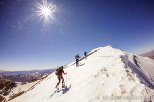
Naturally, we set our sights on the range’s highpoint, Mount Ellen. At around 11,600 feet, a 3 hour hike and skin got us up to the summit ridge where we picked a line to ski back down to camp. The skiing was good and the spring snow was much like home in that it had been hit with the dust. The terrain felt similar to Colorado, with one difference being the presence of giant ponderosa pines, something you just don’t find in Aspen.
It was awesome to finally get here. That said, we both agreed that while it was worth the visit, it wasn’t quite exciting enough to require any further exploration, though the prospect of sticking around to try and see the famed Henry Mountains buffalo herd– one of only three or four free roaming herds believed to exist in North America– was compelling. Then again, and I’ll speak for myself here, I can’t really claim to know much about tracking buffalo.

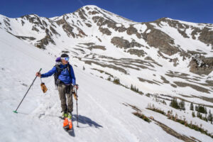
Sean pulls his skins atop Mount Ellen. Behind him, the view to southwest covers the Escalante region and the geologically famous “Waterpocket Fold” of Capitol Reef National Monument(the light colored layer of uplifted rock along the top of the photo).

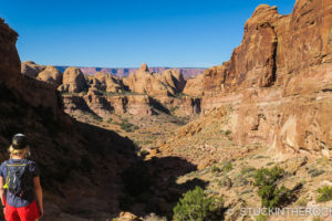
As Sean scouts a line, Robbers Roost country and the San Rafael Swell(lighter colored sedimentary rock) makes for an unusual ski backdrop.

Even though we were far from home, the spring snow had the same white and brown swirl we were used to skiing.

Walking back to camp after skiing, we passed back through the huge stands of burnt Ponderosa’s.

And one of two from “the vault,” (or rather, hard drive) where we looked upon the Henry’s with curiosity, this one from a Goblin Valley sunset in 2007.

And this familiar one, from a trip Sean and I made to Dark Canyon in 2005, where the sunset lit up the sky behind the Henry Mountains and a pinion pine.
So I can finally check “Ski the Henry’s” off my list. Next stop, the Abajo Mountains.


3 Comments
Leave your reply.